|
View Poll Results: When will the ring road be completed?
|
|
1-3 years
|
   
|
8 |
3.85% |
|
4-7 years
|
  
|
91 |
43.75% |
|
7-10 years
|
  
|
65 |
31.25% |
|
10-20 years
|
  
|
20 |
9.62% |
|
Never
|
  
|
24 |
11.54% |
 10-17-2016, 08:23 PM
|
#2841
|
|
Franchise Player
Join Date: Aug 2009
Location: wearing raccoons for boots
|
Looks like its done that way to make use of the bridges they have to build and to not have to build more.
|

|

|
|
10-17-2016, 08:40 PM
|
#2842
|
|
Franchise Player
Join Date: Nov 2009
Location: Calgary
|
Yeah especially in a project where they under bid the other guys by $100 million. They're sure as hell not building a flyover that eats 25% of that so if there's no way to get it underneath the 22X bridges without affecting them (or anything else) then it's a no go. I just spent a couple of minutes trying and I don't really see a way.

|
|
|
|
|
10-17-2016, 08:50 PM
|
#2843
|
|
Voted for Kodos
|
Quote:
Originally Posted by calgarygeologist

I don't understand why the off ramp has to curve/loop back on itself. Once that exit way passes over Macleod they should just curve it north so join up with Macleod. Looping it south in a circle is stupid.
|
That would require at least 2 more bridge structures it looks like, and they have the room.
|
|
|
|
|
10-17-2016, 08:57 PM
|
#2844
|
|
Voted for Kodos
|
Quote:
Originally Posted by Acey
you can see the existing Glenmore/Sarcee intersection pretty much sits right on the new W-N ramp... if that pavement doesn't need to be at a different elevation it would only have to be a huge mess from maybe the latter part of 2019 till opening.
.
|
With the utility work done right beside Sarcee this summer, I bet the existing roadway just becomes the new ramp, almost as is.
|
|
|
|
|
10-17-2016, 08:59 PM
|
#2845
|
|
Voted for Kodos
|
Quote:
Originally Posted by Acey
Yeah especially in a project where they under bid the other guys by $100 million. They're sure as hell not building a flyover that eats 25% of that so if there's no way to get it underneath the 22X bridges without affecting them (or anything else) then it's a no go. I just spent a couple of minutes trying and I don't really see a way.
|
I don't think that is even close to minimum radius requirements for that ramp
|
|
|
|
|
10-17-2016, 09:15 PM
|
#2846
|
|
First Line Centre
|
Thanks for all the info Acey!
I've only been on the West side for a few months, but man as soon as September hit Glenmore got terrible. Half the traffic is just from cramming 3 lanes into one going east at the Sarcee interchange, and 2 lanes into one going west on highway 8.
And I don't even drive it in peak times and there's no snow yet!
Let alone to get deep South (which isn't too bad right now), and deep North - very glad this project is happening and on a great timeline too.
__________________
ech·o cham·ber
/ˈekō ˌCHāmbər/
noun
An environment in which a person encounters only beliefs or opinions that coincide with their own, so that their existing views are reinforced and alternative ideas are not considered.
|
|
|
|
|
The Following User Says Thank You to TheSutterDynasty For This Useful Post:
|
|
|
10-17-2016, 09:54 PM
|
#2847
|
|
Franchise Player
Join Date: Nov 2009
Location: Calgary
|
Quote:
Originally Posted by You Need a Thneed
I don't think that is even close to minimum radius requirements for that ramp
|
Not even remotely close, the gigantic radius of the other two flyovers is a pretty good indicator of how far off it would be. It does, however, look like they have a few meters to expand the radius of the loop which would help a smidge.
|
|
|
|
|
10-18-2016, 07:24 AM
|
#2848
|
|
In the Sin Bin
|
Quote:
Originally Posted by Mazrim
Did you find the Glenmore causeway and Elbow/5 Street interchanges to be bad? Did you find Deerfoot and Stoney in the South to be bad? I assume it will be similar. There's lots of land to move the roads around while they do the work.
|
No, but there were plenty of options to get around GE5 if needed and Stoney/Deerfoot S was already half constructed when the Deerfoot extension was built. Glenmore/Sarcee is a chokepoint. Though as others mentioned, MacLeod/22x will certainly be much worse.
|
|
|
|
|
10-18-2016, 11:49 AM
|
#2849
|
|
Franchise Player
Join Date: Jul 2005
Location: 555 Saddledome Rise SE
|
Love the road planning nerdery. Always kind of wanted to take a course in in university.
So would the optimal intersection of two perpendicular roads from a traffic flow perspective and ignoring costs be 4 of those big looping ramps for left turns?
|
|
|
|
|
10-18-2016, 12:26 PM
|
#2850
|
|
Franchise Player
|
Quote:
Originally Posted by Frequitude
Love the road planning nerdery. Always kind of wanted to take a course in in university.
So would the optimal intersection of two perpendicular roads from a traffic flow perspective and ignoring costs be 4 of those big looping ramps for left turns?
|
I like this setup.

|
|
|
|
|
10-18-2016, 12:33 PM
|
#2851
|
|
First Line Centre
|
I am still not impressed that the city can't close the loop (literally) with the Glenmore to COP portion left out right now with no time table for completion...
|
|
|
|
|
The Following 3 Users Say Thank You to lazypucker For This Useful Post:
|
|
|
10-18-2016, 01:14 PM
|
#2852
|
|
First Line Centre
|
How is the access into Shawnessy shopping are (home depot) going to work with the new interchange? Looks like no in/out access behind Home Depot and no access to the road west of the LRT track off of 22x west.
|
|
|
|
|
10-18-2016, 01:27 PM
|
#2853
|
|
In the Sin Bin
|
Quote:
Originally Posted by lazypucker
I am still not impressed that the city can't close the loop (literally) with the Glenmore to COP portion left out right now with no time table for completion...
|
Wouldn't it be the province that can't close the loop? 201 is a Provincial highway, after all.
Though really, all three levels of government need to get on that so they can re-align the TCH along Highway 901 and south Stoney/Tsuut'ina Trail.
Incidentally, is there any reason why it is "Tsuut'ina Trail" instead of "Tsuu T'ina Trail"?
|
|
|
|
|
10-18-2016, 01:47 PM
|
#2854
|
|
In the Sin Bin
|
Quote:
Originally Posted by rohara66
How is the access into Shawnessy shopping are (home depot) going to work with the new interchange? Looks like no in/out access behind Home Depot and no access to the road west of the LRT track off of 22x west.
|
I think there's something up with that rendering as there is no access to Silverado at all for Westbound traffic.
Neither at Sheriff King Road or James McKevet.
|
|
|
|
|
10-18-2016, 02:04 PM
|
#2855
|
|
Scoring Winger
Join Date: Jul 2009
Location: Bowness
|
Quote:
Originally Posted by calgarygeologist
I like this setup.
|
Is there a tipping point in climates like ours where increased bridging like the above increases winter deck icing and accidents, thus reducing traffic flow when averaged over the whole year?
Last edited by Bownesian; 10-18-2016 at 02:06 PM.
|
|
|
|
|
10-18-2016, 02:06 PM
|
#2856
|
|
Franchise Player
Join Date: Mar 2015
Location: Pickle Jar Lake
|
They just have to remember to plow from top to bottom. 
|
|
|
|
|
The Following 2 Users Say Thank You to Fuzz For This Useful Post:
|
|
|
10-18-2016, 02:54 PM
|
#2857
|
|
Franchise Player
Join Date: Feb 2006
Location: Calgary, AB
|
Quote:
Originally Posted by Resolute 14
Incidentally, is there any reason why it is "Tsuut'ina Trail" instead of "Tsuu T'ina Trail"?
|
That is now their preferred spelling.
__________________
Turn up the good, turn down the suck!
|
|
|
|
|
The Following User Says Thank You to getbak For This Useful Post:
|
|
|
10-18-2016, 03:00 PM
|
#2858
|
|
One of the Nine
|
Quote:
Originally Posted by polak
I think there's something up with that rendering as there is no access to Silverado at all for Westbound traffic.
Neither at Sheriff King Road or James McKevet.
|
Pretty sure I remember reading that there wont be any access for Silverado at Sherrif King/6th st.
Mckevitt is going to be a full interchange though. And I think the city is planning on extending 194th to Mckevitt (or whatever it's called south of 22x) so that Silverado residents do have a reasonable way to get on to Stoney.
|
|
|
|
|
10-18-2016, 03:16 PM
|
#2859
|
|
Franchise Player
Join Date: Mar 2015
Location: Pickle Jar Lake
|
Quote:
Originally Posted by polak
I think there's something up with that rendering as there is no access to Silverado at all for Westbound traffic.
Neither at Sheriff King Road or James McKevet.
|
I think this is the current plan for that area:
https://www.transportation.alberta.c...eod-162Ave.pdf
|
|
|
|
|
10-18-2016, 03:20 PM
|
#2860
|
|
Franchise Player
Join Date: Nov 2009
Location: Calgary
|

Quote:
Originally Posted by Frequitude
Love the road planning nerdery. Always kind of wanted to take a course in in university.
So would the optimal intersection of two perpendicular roads from a traffic flow perspective and ignoring costs be 4 of those big looping ramps for left turns?
|
A stack is the theoretically perfect interchange.
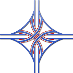
Flyovers could be 2 or more lanes for more capacity if required. Canada has only 1 true stack, in Toronto. Aside from cost, people don't like these because the top level flyovers have to be 25 meters up and it's pretty unsightly, and you just need a ton of land.
If you have unlimited land, you can just swing all the flyovers way out to the side and never need to reach 4 levels, this is sometimes called a "turbine". Here at Stoney/Deerfoot in the NE, you can visualize that if the flyovers went right over the center of the interchange it would be 4 levels, but land is generally plentiful here so there's no need to do it as dirt for embankments is cheaper/easier/safer than 200 meter long monster bridges.

Anthony Henday Drive/Yellowhead Trail in Edmonton is the only interchange in Alberta where two ramps are truly 3rd level, and it's only because there's train tracks and refineries in the way preventing AB Trans' usual style. It's just really expensive.
 Anthony Henday Drive at Yellowhead Trail, Edmonton
 by Acey, on Flickr
You can really see how much of a dump Edmonton is from the top level. It's about 20 meters up.
|
|
|
|
|
The Following 4 Users Say Thank You to Acey For This Useful Post:
|
|
 Posting Rules
|
You may not post new threads
You may not post replies
You may not post attachments
You may not edit your posts
HTML code is Off
|
|
|
All times are GMT -6. The time now is 05:00 AM.
|
|


