Thats brutal that they're taking all the readers out of the buses that have already been installed. Has to be more than a software problem since those are easily fixed.
Back to the 1960s system of the past. I maintain that we have the most out of date bus fare system in the world for any 1st world city over a million people.
Just getting to some news and other topics discussed here over the last little bit. Sorry for the delayed response.
Regarding the news about the Connect smart card system, here is a message from the Calgary Transit representative that works with the Calgary Transit Customer Advisory Group, of which I'm a part.
Quote:
You will soon see in the news that Calgary Transit has cancelled the contract with Telvent, the Connect supplier. They did not deliver a product that met our requirements and timelines. It’s disappointing, but we must have a quality system that’s reliable. Customers will be depending on it.
A number of you participated in the pilot and posted some of your observed problems. Others were noticing too, which resulted in the launch being postponed. During and after that we continued to work with the supplier to rectify the problems; however management eventually reached a conclusion that there was a low probability of success and terminated the contract. Aside from the considerable amount of time that City of Calgary employees have spent working on the project, we did not incur any costs.
The next steps will be to issue another RFP (request for proposal). We will do that in early 2013. Once the new vendor has been chosen we will have a revised timeline, but it is more than a year away.
This topic will be on the agenda of our next meeting. If anyone has any questions or concerns (other than those posted already), I can bring it up and hopefully get some response.
The Following User Says Thank You to frinkprof For This Useful Post:
I tried Calgary Transits new website today. According to it, may bus arrives at 'error on page'. Which city is my address? Seriously CALGARY Transit?
Quote:
Originally Posted by Rathji
Tried the new CT website yesterday as well.
Apparently being at all functional was not on the top 10 list of important things they wanted from the development team.
I'm assuming the above two posts are regarding the new trip planner. Here are some comments I provided on it during the trial/feedback phase.
Quote:
I've checked out the new trip planner, and although I haven't tested all the options exhaustively, I have some thoughts.
My experience with it didn't seem too bad overall actually, compared to the previous one.
Regarding the cumbersome way of inputting addresses, It should either accept multiple conventions or give an example of the convention it will accept. "1830 25 AV NE AV (Calgary)" is not the only way that addresses are noted. It actually isn't even a common convention and I can see it not being many people's first intuition. It wasn't mine.
It should accept the words Ave, Ave., Avenue, St, st., Street, etc.. It should accept both 27 and 27th. It should accept either NE, north east, or northeast. If the software is at a stage where this can't be implemented, at the very least it should give a couple of examples of how it wants the user to input the address.
----------
One thing I was hoping to see that I unfortunately see has not been included is some way of allowing the user to customize the assumptions the software makes on the walking component of the trip. Actually I felt this was a big pitfall with the old one as it seemed to make some inflexible assumptions about the walking part of the trip (it seemed to have a short cut off in either distance or time that one might be willing to walk from the trip origin or to transfer, for example).
For the walking portion of the trip, it should display both the distance and the time it assumes. Perhaps an advanced feature would enable the user to "fix" the walking time accordingly if they can better estimate how long it might take them to cover that distance. I, for example, walk faster than most people, especially if trying to catch a bus. I found that the old trip planner was useless to me based on this alone. I could simply pick a better trip based on published schedules and making my own assumptions as to how quickly I could walk to and from a stop and any walking that was necessary to transfer from one bus or train to another.
Walking times will vary wildly for people depending on age, ability, weather, what they are carrying, etc. I agree that it should make some sort of assumption off the bat, but I think trip times and the best trip option would change if you could make the walking portion customizable.
----------
One final item, the temporal option should allow you to pick either a departure time or an arrival time. For people planning their first trips on the system especially, the departure time is usually what they are interested in as an outcome. They have to get somewhere by a certain time and just want to see when they have to leave so they don't get there too early nor too late, especially too late. If the only option is a departure time, it becomes a trial-and-error process of picking earlier and earlier times to get the latest departure time that will get you to your destination by whatever time you have to be there.
I haven't used the new trip planner much recently, but I have to say that, compared to the last one, it seems alright. Disappointed overall though.
Apparently the whole website was supposed to be completely revamped, but the funding for that was cut such that the only major change made was the trip planner and a small cleanup/format altering of the front page. I was part of a focus group that critiqued the current iteration of the website (just prior to the trip planner change) in the spring. The members of our group really gave the current website a poor review and suggested many changes.
I think the best part about the new trip planner is there is a link to Google Maps on the front page, right below the link to trip planner.
Just did some different searches on how to get to work from home (McKenzie Towne to Downtown):
1. Typed in addresses. Couldn't figure anything out, and One Moment Please spun for a few mins before I gave up. Tried a couple different variations, no improvement.
2. Right clicked and set origin and destination. Worked well, except it was really annoying that the browser context menu opened up and blocked the app context menu. It also only gave me one route suggestion, to use the 117 (and to use the 117 and then transfer to another bus downtown), and totally ignored the option I wanted to use, which was the 302 . That suggestion actually had me leaving 3 minutes in the past (ie it was 6:34 and the time it gave me that I had to leave was 6:31).
3. I tried to find the 302 McKenzie Towne park and ride terminal to fix the issue in 2. I first tried the "Stop" menu in origin. Not only was the only option to search by stop number, but the drop down menu was slow to populate, and only populated a few a t a time, rather than having a entire list to scroll through. I then tried to use the Landmarks, thinking it might include park and ride locations as options, but it didn't. I then needed to find the park and ride location on the map and right click to specify origin.
Overall impressions/suggestions.
- I should be able to specify C train stations or park and rides from list of landmarks.
- Address parsing needs to be good enough to at least give you potential options if it can't figure it out exactly.
- Should give multiple route options for all routes that are in the community. For example, 92, 302 and 117 in McKenzie Towne.
- Should give multiple times, or an obvious way to get those additional times if the original options are not suitable (such as leaving 3 minutes in the past, or needing to leave before you are actually ready - ie need to get my coat, shoes, bag ready once I am done at computer)
- The fact that you need to wait, after each movement of the map for it to load before you can move again is really annoying. If I want to find downtown and don't zoom out the exact amount, or move the complete distance in one shot, it forces me to wait to load all the info for the place I actually stopped at (for example, Douglas Glen).
__________________
"Wake up, Luigi! The only time plumbers sleep on the job is when we're working by the hour."
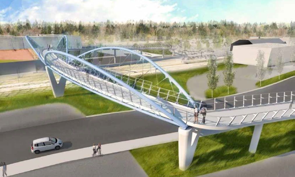
The design of a new pedestrian bridge for Heritage Station was at Calgary Planning Commission recently. It will link the south station entrance with the "London" development and other amenities across the CP tracks.
The South hospital bus has been canceled and the 406 will now come to the McKenzie Towne terminal. This explains the weird "service road" they've built along 52nd and out of the terminal.
The design of a new pedestrian bridge for Heritage Station was at Calgary Planning Commission recently. It will link the south station entrance with the "London" development and other amenities across the CP tracks.
Looks a bit out of the way for Londoner's as well. I thought it was initially proposed a bit further south? Or are they putting it there in the hopes the commercial proposal to the north that has been mothballed actually proceeds?
__________________
Last edited by BlackArcher101; 12-03-2012 at 04:07 PM.
As a pedestrian, I hate crossings like this. They couldn't have designed something more direct?
The bridge goes over CP Rail tracks, which means a higher clearance under the bridge than a normal pedestrian bridge. A taller bridge means longer ramps.
The bridge goes over CP Rail tracks, which means a higher clearance under the bridge than a normal pedestrian bridge. A taller bridge means longer ramps.
What about a surface walkway with some nice landscaping then? It's not like the CP trains take that long to go through, nor are they all that frequent.
The design of a new pedestrian bridge for Heritage Station was at Calgary Planning Commission recently. It will link the south station entrance with the "London" development and other amenities across the CP tracks.
I'll probably never use that bridge, but I think a stair case 'shortcut' would be better, in addition to the ramps. It reminds me of the bridge that goes over Bow Tr. directly across from Safeway/Westbrook mall. When you're making your way up the ramp, it gets slippery in winter; and when you see your bus coming, winding down the ramp adds precious seconds if your bus isn't going to stop.
Once the WLRT opens, this will never be an issue for me again, mind. But I thought I'd throw my thoughts out there . . .
I like how the drawings make it look like there's grass and trees in the area, and not just a car wash, a used-car dealer, and a bottle depot.
Quote:
Originally Posted by frinkprof
Well while I won't disagree with you that it looks pretty destitute in the area there are both pine trees and grass in those lots. I've always wondered why nothing has been developed in those lots, it looks like prime real estate. On a side note I really miss that sweet tube ride at Bonzai Water Park
__________________
The Oilers are like a buffet with one tray of off-brand mac-and-cheese and the rest of it is weird Jell-O
Airlines don't replace their fleets with drastically different planes every 5 years. They buy the same model to ensure that everything stays compatible. Yes, the technology may be a little different on the inside, but you make sure that the basics are all the same. This makes life a lot easier as you can keep everything else the same and allows for you to adopt new auxiliary technologies (Hey, like protective glass railings) and still keep the whole fleet compatible.
I'm not saying replace the fleet every time a car breaks or you need to add capacity. I'm saying replace the car with something that is similar to what you currently have. If some amazing new technology comes out that would be uncompatible with the current fleet, then you weigh the benefits of the tech versus the cost of upgrading the entire fleet.