 03-26-2009, 11:18 AM
|
#1
|
|
Not the one...
|
 Bike Route
From Elbow & Anderson to downtown (Imperial), anyone know any good hidden bike routes for an early morning commute? Biking down Elbow is kind of a nightmare.
__________________
There's always two sides to an argument, and it's always a tie.
|

|

|
|
03-26-2009, 11:49 AM
|
#2
|
|
Voted for Kodos
|
the centre lane of Deerfoot.
|
|
|
|
|
03-26-2009, 12:30 PM
|
#3
|
|
Franchise Player
Join Date: Jul 2003
Location: In my office, at the Ministry of Awesome!
|
Quote:
Originally Posted by You Need a Thneed

the centre lane of Deerfoot.
|
Thank goodness for Green text.
Otherwise I would have thought that you actually believed the centre lane of Deerfoot is the best place for cyclists to be.
Everyone knows cyclists should be in the left lane of Deerfoot.
__________________
THE SHANTZ WILL RISE AGAIN.
 <-----Check the Badge bitches. You want some Awesome, you come to me!
|
|
|
|
|
The Following User Says Thank You to moncton golden flames For This Useful Post:
|
|
|
03-26-2009, 01:28 PM
|
#5
|
|
First Line Centre
Join Date: Nov 2007
Location: Airdrie, Alberta
|
If you are riding down elbow feel free to catch a ride on my hood 
|
|
|
|
|
03-26-2009, 02:12 PM
|
#6
|
|
Lifetime Suspension
|
Isn't it just a matter of getting over to the Bow River pathway?
|
|
|
|
|
03-26-2009, 03:49 PM
|
#7
|
|
CP Pontiff
Join Date: Oct 2001
Location: A pasture out by Millarville
|
Quote:
Originally Posted by moncton golden flames
|
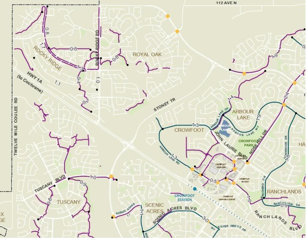
A pathway map:
http://www.calgary.ca/docgallery/BU/...thways_map.pdf
Hit the zoom. From Glenmore Reservoire, you should be able to follow the Elbow River path into the downtown or near it. I remember it not being quite that simple but once you've done it a few times you'll remember the route.
Alternatively, you'd go south from Elbow/Anderson into Canyon Meadows, to Fish Creek Park, then it's bicycle path all the way east to the Bow River, then follow the Bow downtown. But that's a long, long haul every day. Probably 25 or 30 km or something like that, one way.
Cowperson
__________________
Dear Lord, help me to be the kind of person my dog thinks I am. - Anonymous
|
|
|
|
|
The Following User Says Thank You to Cowperson For This Useful Post:
|
|
|
03-26-2009, 05:29 PM
|
#8
|
|
Franchise Player
|
google maps will give you option to get directions for car, mass transit, and walking. i guess walking might be close to a bike route.
__________________
AS SEEN ON TV
|
|
|
|
|
05-29-2009, 12:18 PM
|
#9
|
|
Franchise Player
Join Date: Sep 2005
Location: Calgary, AB
|
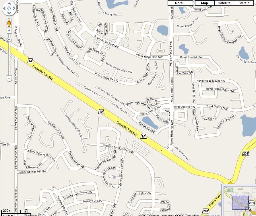
I need to get up to Royal Oak tonight on my bike but I'm not familiar with either Tuscany or Royal Oak.
Are there any pedestrian overpasses to get across Crowchild in that area? If not, what is the best way?
Thanks
|
|
|
|
|
05-29-2009, 12:23 PM
|
#10
|
|
Powerplay Quarterback
|
They finally installed pedestrian lights at 12 mile coulee road and crowchild. I still dont like using them but that is really the only way across tuscany to rocky ridge.
|
|
|
|
|
05-29-2009, 12:23 PM
|
#11
|
|
Celebrated Square Root Day
|
Quote:
Originally Posted by Bring_Back_Shantz
Thank goodness for Green text.
Otherwise I would have thought that you actually believed the centre lane of Deerfoot is the best place for cyclists to be.
|
I ran out of thanks, but yes, this sarcastic reply is exactly how I feel about green text. Personally, I don't like to see it ever, if you point out sarcasm, it defeats the purpose of sarcasm, but biking down deerfoot? I'm pretty sure there isn't one poster on CP that would go "OMG, are you seriously suggesting that people ride their bike down deerfoot!!?! That's ridiculous!!" if you didn't use green text.
|
|
|
|
|
05-29-2009, 12:35 PM
|
#12
|
|
Franchise Player
Join Date: Oct 2001
Location: sector 7G
|
Gozer, my commute takes me from Harvest Hills way up north all the way to Southland. I used to ride Elbow as well but have switched to a combination of Haddon Rd, 5st SW, elbow river pathway and then 5 St SW again into downtown. It works really well. It's one of the "bike routes" on one of the links above.
|
|
|
|
|
The Following User Says Thank You to habernac For This Useful Post:
|
|
|
05-29-2009, 12:41 PM
|
#13
|
|
Playboy Mansion Poolboy
Join Date: Apr 2004
Location: Close enough to make a beer run during a TV timeout
|
If you are like me and some of the content of the interactive map is blocked at work, there's a full PDF here: http://www.calgary.ca/docgallery/BU/...thways_map.pdf
|
|
|
|
|
05-29-2009, 12:46 PM
|
#14
|
|
Franchise Player
Join Date: Oct 2001
Location: sector 7G
|
Quote:
Originally Posted by habernac
Gozer, my commute takes me from Harvest Hills way up north all the way to Southland. I used to ride Elbow as well but have switched to a combination of Haddon Rd, 5st SW, elbow river pathway and then 5 St SW again into downtown. It works really well. It's one of the "bike routes" on one of the links above.
|
the first time you take it, you may get a little turned around when you're approaching Chinook Mall, but you'll figure it out quickly. Some really nice houses in the Stanley Park area.
I'm cranking out 200+ km a week on my commute, which is great because finding ride time with 2 young kinds at home is tough. And on my road bike, I can beat the bus/train combination.
|
|
|
|
|
05-29-2009, 01:41 PM
|
#15
|
|
Playboy Mansion Poolboy
Join Date: Apr 2004
Location: Close enough to make a beer run during a TV timeout
|
So, speaking of biking down Deerfoot, looking at the map it looks like there's a bike path that pretty much follows Deerfoot from Douglasdale into downtown. I know there's one monster hill (read- too steep for the fat guy) going by Diamond Cove, but how is the rest of it for being level?
|
|
|
|
|
05-29-2009, 01:51 PM
|
#16
|
|
Franchise Player
Join Date: Oct 2001
Location: sector 7G
|
I don't ride that way often, but there is one more, near Dover maybe? The rest is pretty much clear sailing.
|
|
|
|
|
05-29-2009, 02:32 PM
|
#17
|
|
First Line Centre
|
Quote:
Originally Posted by Cowperson
Alternatively, you'd go south from Elbow/Anderson into Canyon Meadows, to Fish Creek Park, then it's bicycle path all the way east to the Bow River, then follow the Bow downtown. But that's a long, long haul every day. Probably 25 or 30 km or something like that, one way.
Cowperson
|
Have they rebuilt the path along the Bow River. I used to ride this all the time. It was a great loop to do on a Saturday afternoon, to start in Fish Creek, ride up the Bow River past Caburn Park, Beaverdam Flats, the Bird Santuary, and all the way to Fort Calgary, then I would turn south and ride through the Stampede grounds, past Lindsay Park, to the Glenmore Resevoir where you could get on a path from the SW corner that connects back to Fish Creek.
However, the last time I tried cycling the route, a few years ago, I discovered that the path had fallen into the River somewhere between Anderson and Southland drives during the big flood. When I inquired as to when it may be fixed, I was informed that there was no timetable, which made me think it may never been fixed.
Has anyone cycled that section that would connect Fish Creek with Caburn Park on the Bow River? Is it a continuous path again?
|
|
|
|
|
05-29-2009, 02:32 PM
|
#18
|
|
Franchise Player
Join Date: Sep 2005
Location: Calgary, AB
|
Quote:
|
They finally installed pedestrian lights at 12 mile coulee road and crowchild. I still dont like using them but that is really the only way across tuscany to rocky ridge.
|
Thanks, that's exactly what I'll do.
|
|
|
|
|
05-29-2009, 02:40 PM
|
#19
|
|
Playboy Mansion Poolboy
Join Date: Apr 2004
Location: Close enough to make a beer run during a TV timeout
|
Quote:
Originally Posted by Eric Vail
Have they rebuilt the path along the Bow River.
|
When I drive south/east on Deerfoot and look over to my right as I cross the river, I can see the bike path rebuilt. (and at a higher elevation too.) Is this where you are talking about?
|
|
|
|
|
05-29-2009, 02:43 PM
|
#20
|
|
Powerplay Quarterback
Join Date: Apr 2006
Location: Mahogany, aka halfway to Lethbridge
|
Quote:
Originally Posted by Eric Vail
Have they rebuilt the path along the Bow River. I used to ride this all the time. It was a great loop to do on a Saturday afternoon, to start in Fish Creek, ride up the Bow River past Caburn Park, Beaverdam Flats, the Bird Santuary, and all the way to Fort Calgary, then I would turn south and ride through the Stampede grounds, past Lindsay Park, to the Glenmore Resevoir where you could get on a path from the SW corner that connects back to Fish Creek.
However, the last time I tried cycling the route, a few years ago, I discovered that the path had fallen into the River somewhere between Anderson and Southland drives during the big flood. When I inquired as to when it may be fixed, I was informed that there was no timetable, which made me think it may never been fixed.
Has anyone cycled that section that would connect Fish Creek with Caburn Park on the Bow River? Is it a continuous path again?
|
If you mean by the Southland offleash area, then yes, it's been rebuilt, slightly relocated away from the river and fenced off from the loose dogs. (We walk our dogs there regularly and they've really upgraded the bike trail)
__________________
onetwo and threefour... Together no more. The end of an era. Let's rebuild...
|
|
|
|
 Posting Rules
|
You may not post new threads
You may not post replies
You may not post attachments
You may not edit your posts
HTML code is Off
|
|
|
All times are GMT -6. The time now is 03:06 AM.
|
|


