This is the first part of a series I've been meaning to do for awhile. I will give a look at what other cities are doing. For now it will be a listing (much like the one on the first page) of extension projects in other cities. After awhile, I may get into more detailed profiles of select cities. Not sure how fast this will roll out, but probably only when I get some time to work on it.
I know this is inherently off-topic, but I'd rather keep it in here rather than in its own thread.
Heavy Rail
Honolulu
Hololulu Rail Transit
www.honolulutransit.org/
Description: Honolulu's first rail transit line will connect downtown Honolulu through Pearl Harbour, the Honolulu International Airport, Aloha Stadium to the western suburbs of Pearl City and Kapolei. It will operate on predominantly elevated rail.
Length: 20 miles (32 km)
Stations: 21
Opens: Kapolei to Aloha Stadium, 2015; to Middle Street, 2017; full line to Ala Moana Center, 2019.
Maps and Renderings:
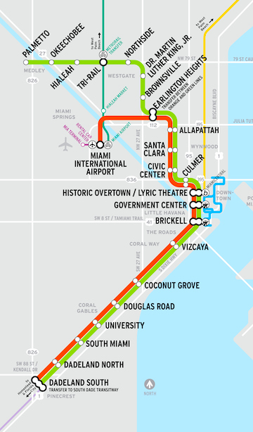
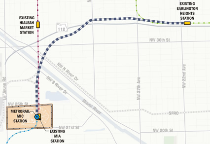
Miami
MetroRail Airport Rail Link
http://www.miamidade.gov/transit/imp...portlink.asp#4
Description: The Airport Rail link will be an elevated line that connects Miami's existing Earlington Heights Station on the Green Line to Miami International Airport. The Airport Rail link is the first part of the Orange Line which will eventually link Miami with western suburb Sweetwater and northern suburb Carol City.
Length: 2.4 miles (4 km)
Stations: 1
Opens: July 28, 2012
Maps and Renderings:
New York
Second Avenue Subway
http://www.mta.info/capconstr/sas/
Description: The long-planned Second Avenue Subway is under construction and will provide service along the east side of Manhattan Island. The need for a Second Avenue Subway to relieve the immense pressure on the rest of New York's subway system - the Lexington Avenue line in particular, was identified as early as the 1920s but has hit a number of stumbling blocks up to now.
Length: Phase 1: 2 miles (3.2 km), Full buildout: 8.5 miles (13.7 km)
Stations: 16
Opens: Phase 1: 2016
Maps and Renderings:
Number 7 Subway Extension
http://www.mta.info/capconstr/7ext/
Description: The number 7 subway line will be extended west along 42nd Street and south along 11th Avenue to W 34th Street. This extension is part of the grander Hudson Yards Redevelopment.
Length: 1.5 miles (2.4 km)
Stations: 1 now, 1 optional at a later date
Opens: June 2014
Maps and Renderings:
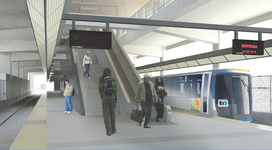
San Francisco
BART Warm Springs/Fremont Extension
http://www.bart.gov/about/projects/wsx/
Description: This extension goes from the existing southern BART terminus station Fremont along a primarily at-grade alignment into the Fremont municipality.
Length: 5.4 miles (8.6 km)
Stations: 2
Opens: 2015
Maps and Renderings:
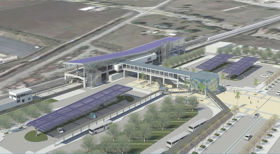
BART Berryessa Extension
http://www.bart.gov/about/projects/wsx/
Description: The Berryessa Extension will bring the BART system south from Warm Springs/Fremont Station south into San Jose. It is part of the longer-term project of extending BART into the Silicon Valley. Construction will be concurrent with the Warm Springs/Fremont extension. The line will run predominantly at-grade.
Length: 10 miles (16 km)
Opens: 2018
Stations: 2
Maps and Renderings:
Washington DC
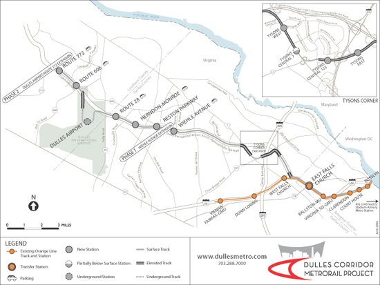
Dulles Corridor Metrorail Project (Silver Line)
http://www.dullesmetro.com/
Description: This extension project will link the existing Orange Line at East Falls Church station westward to Tyson's Corner, Dulles International Airport and beyond. The line will run in a predominantly elevated alignment.
Length: 12 miles (19 km)
Stations: 11 now, 1 optional infill station may be be added later
Opens: Phase 1 to Wiehle/Reston East Station in 2013. Phase 2 to Dulles International Airport and further to Route 772 in 2016.
Maps and Renderings:
Next Part: Light Rail Projects