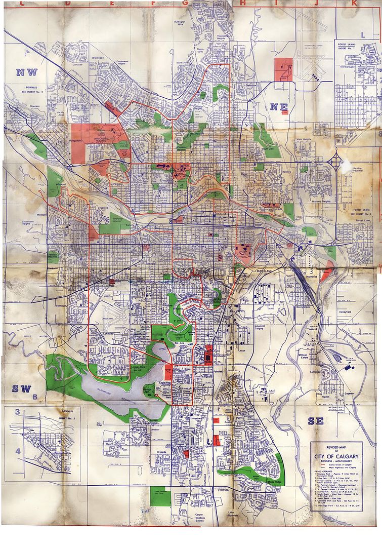
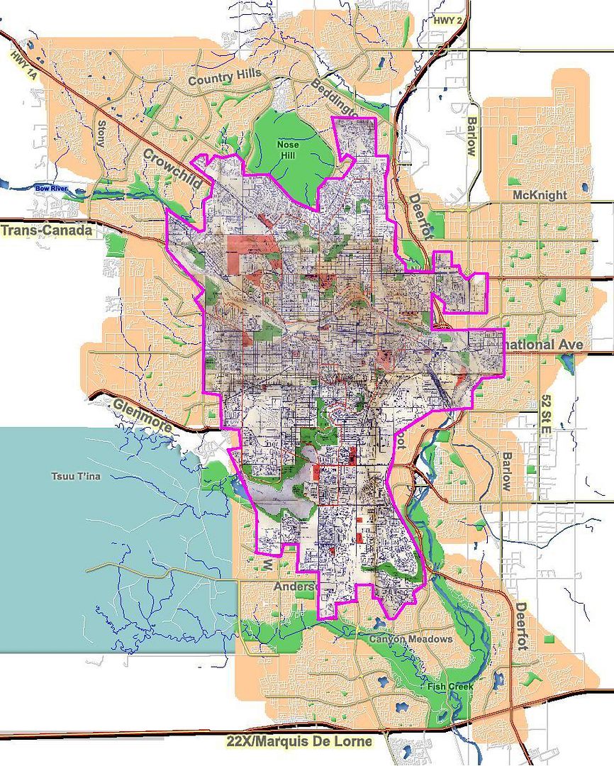
While stripping the interior out of my wife's '72 GTO a couple of years back, I found a map from 1969 buried under the seats, it's pretty interesting to see the differences. Here's the map scanned, the basic residential areas overlayed on a 2010 map, and the scanned map file if you want to peruse the map (just right click saving the JPG doesn't keep the street names very clear)
__________________ https://www.reddit.com/r/CalgaryFlames/
Im always amazed these sportscasters and announcers can call the game with McDavids **** in their mouths all the time.
Last edited by ricosuave; 05-26-2010 at 07:21 PM.
The Following 6 Users Say Thank You to ricosuave For This Useful Post:
Try this one on for size - plan of the town of Calgary 1891, WARNING: it's huge if you click the link and blow it up:
Some notes:
1. The title block in the bottom right mentions that it was compiled by Messrs Jephson and Wheeler D.L. Surveys. The "D.L." stands for Dominion Lands, as in they were Dominion Land Surveyors. There are no more Dominion Land Surveyors. Since it was done in 1891, this predates the existence of Alberta Land Surveyors, since Alberta wasn't a province until 1905. I'm 90% sure that the "Wheeler" in question is this guy. A.O. Wheeler was quite a historic figure in the Canadian surveying field. He is credited with naming lots of mountains in the rockies, as well as being a pioneer in photogrammetry.
2. The streets now named 14th Street West (First Street on the map), 4th Street West (Ross Road on the map), and 6th Street East are shown on the map as "government road allowances." The north/south running road allowances (range roads) are generally one mile apart. Also, the street directly east of the one labelled "Fourth Av." on the eastern side of the map, is also a G.R.A., and is now 15th Street East.
Not shown on the map is the next north/south Road allowance directly east of this one, which is actually the 5th meridian, which today's Barlow Trail follows in its straight portion. Also, there is actually Meridian Road in the northeast which picks up from Barlow where it deviates a bit from the actual meridian. This meridian is at exactly 114 degrees longitude west of Greenwich, England, or the prime meridian. The 4th meridian defines the Alberta/Saskatchewan border. The 1st meridian is just west of Winnipeg, where the Dominion Land Surveying system began.
Other north/south road allowances in Calgary are 37th, 53rd (Sarcee), 69th, 85th, and 101st Streets West; 36th, 52nd, and 84th Streets East.
Part of the new city limits in the east are at Range Road 284 (likely future 116 Street East).
3. 17th Ave. (Notre Dame Street on the map) is noted as an east/west Government Road Allowance. This is the only one shown on the map, since the next one to the south is now 50th Ave. South, and the next one to the north is 16th Ave. North. Road allowances that run east/west (township roads) are generally every two miles.
Other east/west road allowances in Calgary are McKnight Blvd. (48th Ave. North), 80th Ave. North, and the eastern portion of Country Hills Blvd. together with 112th Ave. in the Northwest. In the South, Heritage Drive together with Glenmore Trail east of Deerfoot, Anderson Road together with 114th Ave., 146th Ave/James McKevitt Road, and 22X.
The city limits in the north are at Township Road 262 (likely future 176th Ave. North).
Last edited by frinkprof; 05-26-2010 at 08:04 PM.
The Following 7 Users Say Thank You to frinkprof For This Useful Post:
There is something about a big city that makes me feel uncontrollably uneasy.
I would never last a month in New York, I would just feel way to anonymous. Its nice to be able to go some place's where people remember you, or know you.
Communities that were their own separate towns/villages at one time:
-Crescent Heights was a separate village from 1908 until 1911
-Bowness was a separate town until 1963, and had its own streetcar line starting in 1911
-Forest Lawn was its own town until 1961
-Montgomery was separate village/town from 1911 until 1963
-Midnapore was its own town until 1961, it had its own CP Rail train station (which inspired the design of the Fish Creek - Lacombe LRT station built in 2001)
-Beddington was never a town of its own, but is named after a CP Rail train station that existed there long before it became an established residential community of Calgary in 1979
-Shepard is the newest addition, amalgamated in 2007. It had its own CP Rail train station in 1884.
Next on the list: Chestermere? De Winton? Janet? Conrich (where CN Rail will be building their new railyard)? Balzac? Actually the southern half of the Balzac townsite is now City of Calgary as of 2007.
Here's some pics:
1969
7th Ave. South under construction for LRT in 1978, with notes:
There is something about a big city that makes me feel uncontrollably uneasy.
I would never last a month in New York, I would just feel way to anonymous. Its nice to be able to go some place's where people remember you, or know you.
My dad lived in Okotoks for the past 15 years, and I'd been visiting it once or twice a year and it seemed to double in size every year... I'm still waiting for it to grow into Calgary and become South South Calgary
I've lived in Calgary all my life (born in '75) and it's amazing to see some of this stuff. I actually remember hearing about the villages around the city.
I heard a neat thing on the radio regarding the pronunciation as well as the meaning of a few ofour roads. Eg:
Marquis of Lorne trail is pronounced "Markwiss", which makes no sense to me as I thought it was French?
Richard road isn't pronounced in the english sense....it's actually named after Rocket Richard. So it's "Reeshard" road.
Marquis of Lorne trail is pronounced "Markwiss", which makes no sense to me as I thought it was French?
It's a British title of French origin. Because the British don't particularly like the French, they Anglicized the pronunciation (if you follow boxing, you will sometimes hear of the Marquis of Queensbury Rules, which is also pronounced in the English way). It is also sometimes spelt, "Marquess" to match the pronunciation.
The Marquis of Lorne was the Governor General of Canada from 1878 to 1883. He was married to Queen Victoria's daughter, Princess Louise Caroline Alberta.
Lake Louise, the town of Caroline, and the Province of Alberta itself (one of the Northwest Territories at the time) were all named in her honour.
__________________
Turn up the good, turn down the suck!
The Following 3 Users Say Thank You to getbak For This Useful Post:
The Marquis of Lorne was the Governor General of Canada from 1878 to 1883. He was married to Queen Victoria's daughter, Princess Louise Caroline Alberta.
Lake Louise, the town of Caroline, and the Province of Alberta itself (one of the Northwest Territories at the time) were all named in her honour.
So what?
Why is he Trail worthy? I think his ol' lady's name is plastered around enough for the both of 'em.
Isn't it Spruce Meadows Trail west of Macleod? I think it should be east also. Enough of this Lorne Marquis character.
There is something about a big city that makes me feel uncontrollably uneasy.
I would never last a month in New York, I would just feel way to anonymous. Its nice to be able to go some place's where people remember you, or know you.
Oddly enough people do get to know you in NYC. It's obviously a big city, but there are so many mom and pop type places that you get to know the people the work there. Like the guy who makes me a club sandwich at 4am every weekend, he knows me, I just don't ever remember him
The Following User Says Thank You to valo403 For This Useful Post:
While stripping the interior out of my wife's '72 GTO a couple of years back, I found a map from 1969 buried under the seats, it's pretty interesting to see the differences. Here's the map scanned, the basic residential areas overlayed on a 2010 map, and the scanned map file if you want to peruse the map (just right click saving the JPG doesn't keep the street names very clear)
Thats pretty cool to look at. Anyone notice the runways at Lincoln Park? I didnt realize they were still there that late in the day. I thought they were kind of gone shortly after the war. Also old McCall Field's runways...completely different alignment. Looks like they just blew it all up and redid the whole thing back in the 70's. I wonder how the airport operated while they redid it all. Anyone here old enough to remember?
Also old McCall Field's runways...completely different alignment. Looks like they just blew it all up and redid the whole thing back in the 70's. I wonder how the airport operated while they redid it all. Anyone here old enough to remember?
The current 3 runways are on that map, I think the other smaller runways they just disconnected from the runways and taxiways over time, and probably removed the asphalt at some point later on.
The CMA is over a million, but the actual population of Calgary proper is under 1 million.
CMA includes airdrie, Cochrane, Strathmore etc. so that puts us well over 1 mill. The population inside the Calgary borders would be 980,000+.
I'm pretty sure Calgary proper passed the million mark a year or two ago. Didn't Bronconnier meet the baby in the hospital and give the parents all sorts of stuff to celebrate the event?
Edit: That population of 988,000 is from 2006 not 2010.
I'm pretty sure Calgary proper passed the million mark a year or two ago. Didn't Bronconnier meet the baby in the hospital and give the parents all sorts of stuff to celebrate the event?
Edit: That population of 988,000 is from 2006 not 2010.
Quote:
Mayor Dave Bronconnier is declaring that with the population growing by 98 people a day, the first baby born after midnight tonight is the citys millionth resident.
Its an important milestone in our history, Bronconnier said. Whats happening in Calgary is nothing short of phenomenal.
The current 3 runways are on that map, I think the other smaller runways they just disconnected from the runways and taxiways over time, and probably removed the asphalt at some point later on.
Yup, you're right Bigtime. I went back and took another look. I was looking at that old map through windows photo gallery and was zoomed too far in. All I was looking at was that mess of smaller runways in the south east corner!