Gps tracking supposed to be in and functional for bus timing sometime soon - maybe the end of the year? The signs are part of that process. Personally I think they should have a qr code on a panel at each stop, then have it open a transit app that is populated with real time gps data.
That's too efficient, cost effective and easy to implement for the city's liking.
The Following User Says Thank You to Cowboy89 For This Useful Post:
No need for a QR code if it's just going to link to the app anyways.
Won't they have an app/site that shows times based on the GPS anyways? I'd like to have both, screens at LRT stations and major bus stops with the ability to check each stop remotely via smartphone or pc.
__________________
The Following 2 Users Say Thank You to BlackArcher101 For This Useful Post:
No need for a QR code if it's just going to link to the app anyways.
Won't they have an app/site that shows times based on the GPS anyways? I'd like to have both, screens at LRT stations and major bus stops with the ability to check each stop remotely via smartphone or pc.
If the app does that, then you are 100% correct.
__________________
"Wake up, Luigi! The only time plumbers sleep on the job is when we're working by the hour."
Location: Close enough to make a beer run during a TV timeout
Exp:
One of the updates to CT's "Next Stop" app was a map feature. Currently it just uses your phone's GPS to find out where you are and where the nearest stops are. Seems like adding real time Transit info would be a next logical step.
One of the updates to CT's "Next Stop" app was a map feature. Currently it just uses your phone's GPS to find out where you are and where the nearest stops are. Seems like adding real time Transit info would be a next logical step.
Just to make the distinction - this is not a Calgary Transit app.
Some information as a primer for the upcoming SE Transitway open houses coming up. Just describes the process and where things are at right now (looking at starting a preliminary design with construction as early as 2014).
Here's the dates and locations for the upcoming open houses:
Date Location Address Time Jan. 24 Riverbend Community Hall 19 Rivervalley Drive SE 4 – 8 pm View map Jan. 25 Ramsay Community Hall 1136 – 8 Street SE 4 – 8 pm View map Jan. 26 McKenzie Towne Hall 40 McKenzie Towne Blvd SE 4 – 8 pm
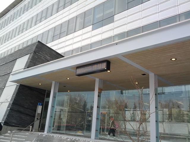
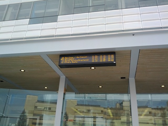
There is now an electronic information sign at one of the main U of C bus stops, as discussed above. It is affixed to the new building (EEEL building) just off 32nd Avenue. It currently just shows the schedule information for the routes that stop there, but it should start showing realtime arrival information (just like the ones on LRT platforms) sometime before 2014 as part of the realtime bus information rollout.
Here's some photos and a video of it in operation:
I would think priority places to have these would be at:
BRT stops
Bus loops at LRT stations (perhaps starting with having one at the new bus shelter that will be built when Chinook closes down this year and is rebuilt)
MRU
Foothills Hospital
Rockyview Hospital
Last edited by frinkprof; 01-19-2012 at 12:14 AM.
The Following 3 Users Say Thank You to frinkprof For This Useful Post:
All good ideas. And many of these possibilities will open up once our bus system is all connected to GPS.
Keep an eye out in the next few weeks for the launch of a new comprehensive long term strategic plan for Calgary Transit. It's a big deal and will have far reaching effects on our transit system. It will also be a process heavy on user/public consultation, so you will all be able to have your say about the future of the system.
__________________
Trust the snake.
The Following 2 Users Say Thank You to Bunk For This Useful Post:
Chinook Station will be closed between January 2013 and June 2013. The existing platform/station head building will be demolished and the new platform/canopy will start construction in May. There will also be a new heated bus shelter building where existing bus loop is.
The new platform will not have a station head building, but will instead have two level-crossing access points on either end, a canopy roof structure and heated shelters on the platform.
Chinook Station will be closed between January (obviously sometime later this month) and June. The existing platform/station head building will be demolished and the new platform/canopy will start construction in May. There will also be a new heated bus shelter building where existing bus loop is.
The new platform will not have a station head building, but will instead have two level-crossing access points on either end, a canopy roof structure and heated shelters on the platform.
It will be closed Jan 2013 to June 2013, not this year.
Hey, what is the anticipated completion date for all of these stations? When can we expect to see the four car trains?
2014 is when the capacity is expected to be there, i.e. all stations will have the platform length and all electrical subsystems will have been upgraded. Actual 4 car operation is another matter and will depend on a few things. There needs to be new train cars ordered to make it happen. There will be a new order of 50 LRVs soon, with some lag time for manufacturing, delivery, testing, and commission. A lot of those cars are needed for replacement of old and/or already retired vehicles though, so how many are left over for any 4 car trains is a wait and see thing, but it could conceivably shortly follow the capacity completion.
The actual 4 car operation won't be all at once and will likely be phased in with a few trains having that extra car at rush hour and ramped up over a period of years until all or most trains are 4 cars in length.
Stations with four car length:
Dalhousie
Shawnessy
Somerset-Bridlewood
McKnight-Westwinds
Crowfoot
Southland
Canyon Meadows
Erlton-Stampede
Brentwood
Whitehorn
All of West LRT (under construction)
Both Martindale and Saddletown (new NE line extension under construction)
All of 7th Avenue, except for Centre Street (under construction), and 10th Street West (to be demolished and replaced by the new 11th Street West (Kerby) Station currently under construction)
Also a note about my post above. I misunderstood, Chinook will close down next year in January, not this month.
Location: Close enough to make a beer run during a TV timeout
Exp:
I went to the one in Riverbend last night. I was pretty disappointed.
I was expecting some new information about the plan for the dedicated BRT route. All that was there was the LRT route plans (which we all know are 10+ years away); with the discussion that they would build some of the infrastructure early to accomidate a dedicated BRT route.
The only good thing was the event was pretty dead; so I had a pretty captive audience with my BRT/Express Bus suggestions:
- Have the BRT got down 7th street instead of 5th downtown. Less congestion, and more of downtown covered.
- The express buses (102, 103, 117, and 151) should not have to go through Quarry Park. Instead they should go straight up 24th street. 1 km shorter, 4 fewer lights and one less bad stop sign.
The only news I really got out of this; they plan on having the 302 BRT start at Seton this year. It will serve Seton, then onto Deerfoot, and onto McKenzie Towne blvd to hit what is now the start of the route.
The BRT is all ready getting full. I don't like how it is getting popular. I miss the Days of being able to sit with no one around me. I am going to have to start going to work at 630 bus instead of the busy later ones.
I also believe all the express buses should be express! When they leave which ever community they are in they should not stop until they get around the downtown core.
Now I am sure if I lived in Riverbend (hopefully one day I will move into my riverbend house) I would change my mind on this since it would be great to be able to hop onto any bus that goes through quarry park. Since I live in NB it pisses me off that express buses run the same route as the BRT
1) taking the first exit and circling around via Promenade Way to get onto the Gate and going onto 52nd St.
2) Taking the second exit, and driving through the strip mall and then to the Gate and 52nd
3) Taking the 3rd exit, going to southbound 52nd and then having things function just as they do now.
1 is good in the fact that it doesn't involve the bus going through the traffic circle very much, but bad because it won't use the existing stop infrastructure. 2 is bad because it faces the same problems as 1, but also adds in very narrow and busy streets with difficult turns. 3 is probably the best, but it involves the bus driving in circles essentially, plus driving almost all the way around the traffic circle.
I will miss the bus constantly waiting for me in Mckenzie Towne though. Getting on at the first stop has its advantages. I will echo fundmark19 in that I miss when it was a bit more empty. I wonder if I will have to give up my 'ideal seat locations' when out of towners go to Seton instead of McKenzie Towne.
__________________
"Wake up, Luigi! The only time plumbers sleep on the job is when we're working by the hour."
Keep in mind that 22x and 52nd Street are currently under major construction. Perhaps the Deerfoot to McKenzie Towne route is temporary to bypass that?
The Following User Says Thank You to Resolute 14 For This Useful Post:
Location: Close enough to make a beer run during a TV timeout
Exp:
Sorry- to clarify the plan for now is for the BRT to actually still stop at the current McKenzie Towne station. The reason it is taking Deerfoot is that 52nd street isn't complete south of Mohagany.